
A general place to start is CreativeCommons Search
| 3D Israel | A variety of virtual tours of Israel using panoramic images |
| AtlasTours Photos | Collections of photos from Jordan, Holy Land, Syria, Lebanon, Iraq, Sinai |
| Bible Lands PhotoGuide (Accordance module [Mac]) |
Version 2 ($69) or updated Version 3 for OS X ($79) - "The Bible Lands PhotoGuide has hundreds of detailed articles describing the most important Biblical locations in Israel and surrounding countries, illustrated with more than 1600 high-quality photographs." |
| BiblePlaces | About 6000 excellent copyrighted photos on this web site by Todd Bolen. To use the pictures, you need to buy the various "Pictorial Library of Bible Lands" CDs which include pre-made PowerPoint slides and extensive explanations. There are some free pics showing the high-resolution quality. |
| BibleWalks | Lots of pictures, nicely organized by location with commentary. (All pictures are copyrighted, but it may be possible to obtain permissions.) |
| Biblical World in Pictures | ($180 retail; available for $150 for Logos or Accordance) "The editors of Biblical Archaeology Review have selected the 1,300 photographs that best tell the story of the Bible through archaeology." |
| Cooperative Digital Resources Initiative | This site has a large collection of images with easy terms of use with attribution. For images of Bible places, you will do well to first click on the "Limit by Collection." "Images of the Ancient Near East" and "Images of the Holy Land" include 1222 pictures from the Southwestern Baptist Theol. Seminary. Most of the pictures are scanned from slides, and the pictures are not particularly attractive. "Selected Photographs of Ancient Near Eastern and Mediterranean Sites" includes 509 pictures from Emory University that are of mixed but somewhat better quality and include more description. |
| eBibleTeacher.com | Has a collection of close to 100 photos of biblical places and things. Images are free with appropriate crediting. |
| Eye on Israel | Interactive site with photos and descriptions |
| Experience Israel: A Virtual Tour of the Holy Land | Excellent collection of well-organized panoramas with written and audio commentary. |
| Flickr | Great photo sharing site. Many pictures have Creative Commons licenses that allow for varieties of use. Searching for tags of biblical sites is a bit frustrating. Use OpenBible.info noted below. |
| GoogleEarth | GoogleEarth is, of course, a great place to get good
quality satellite imagery of a biblical site, but it is the
"layers" that make it such an incredible site. Under the Layers
section, check on: Geographic Web > Panoramio (cf. below) and
Wikipedia. Plenty of pictures will be available linked to every site. In
addition, under Gallery, check on YouTube to get videos of many locations
and National Geographic for more pics. The main drawback is that it
appears that few pictures are copyright clear.
Additionally, if you have your own pictures, load up Google's free Picasa program, and then you can geotag your pics so that they appear at the proper location in GoogleEarth. (Cf. the example pic below.) |
| Historic Pictures | Pictures and sketches from 1937 and earlier, mostly of Jerusalem. |
| HolyLand 3D | A bit like GoogleEarth optimized for biblical work. "Hundreds of photos" linked to the map and dictionaries. |
| Holy Land Photos | As its tagline says, "Free, hi-res images of the Holy Lands." Currently there are 284 sites with 2839 photos in their database. Note the generous permission policy. |
| iLumina | Gold ($90) - Includes 1000+ Holyland photos |
| Images of Archaeological Sites in Israel | Focus on Iron Age sites (Arad, Beersheva, Carmel, Gezer, Hazor, Lachish, Megiddo); many photos with helpful descriptions. Especially note the excellent slideshow video tours of each site. "Attribution, no commercial use" license for using photos. |
| Interactive Satellite Map of the Holy Land | Free download; runs in Internet browser; not a comprehensive collection of sites but still helpful; links to KJV, reference articles, and pictures used with permission from BiblePlaces (cf above). |
| Life in the Holy Land | A well-organized collection of historic pictures and sketches. Generous copyright promoting book/CD sales. |
| Microsoft Virtual Earth | Free, online tool that works like GoogleEarth. Satellite imagery but cf. image below. |
| OpenBible.info - Photos of Bible Places | 13,533 photos of 811 places! Sites are listed alphabetically with hooks into the Flickr tags. Many of the photos also have been linked via Panoramio and may also have location links into Google Earth. Range of photo rights as is typical with Flickr. |
| Panoramas from World Heritage Tour | 13 sites in Israel and Jordan with numerous panoramas |
| Panoramio | User uploaded pictures are geographically linked into Google Earth. This is a great place to upload your pics, but rather than using this site to locate photos, it easier to use GoogleEarth or the OpenBible.info which draw on this service. |
| Photos from Israel | A large collection of photos; note the clear statement on usage |
| QuickVerse Bible Maps | "Over 2,000 brilliant high-resolution color Holy Land photos!" - Seems to be a standard in all QuickVerse packages. |
| SBF Biblical Excursions | Collection of 'excursions' in the biblical world, Holy Land, and Jerusalem with photos and descriptions |
| A Tour of the Holy Land 1831-1910 | A large collection of historic photos of locations throughout the Holy Land |
| Tourist and Tourist agency photos | Do a Google image search
for a specific biblical location will bring up plenty of pictures, some of
them quite nice. The problem is in obtaining permissions for use. As the
graphic below shows, once you get results, there are quick links to a
number of other photos sites.
Another good site provides an Introduction to Ephesus. |
| The Virtual World Project | Focuses on the ancient eastern Mediterranean with resources for Greece, Turkey, Israel, and Jordan. Search by map location, features (e.g., churches, synagogues, temples), or periods (Paleolithic through Crusader). Excellent collection of notes and pictures, including many 360 degree views. |
| Walking In Their Sandals | ($30) - 500+ photos plus videos and 360 degree photo bubbles. |
| Have some other great suggestions for pictures of biblical sites? Let me know. |
| Hazor Satellite views | |
| Google Earth | 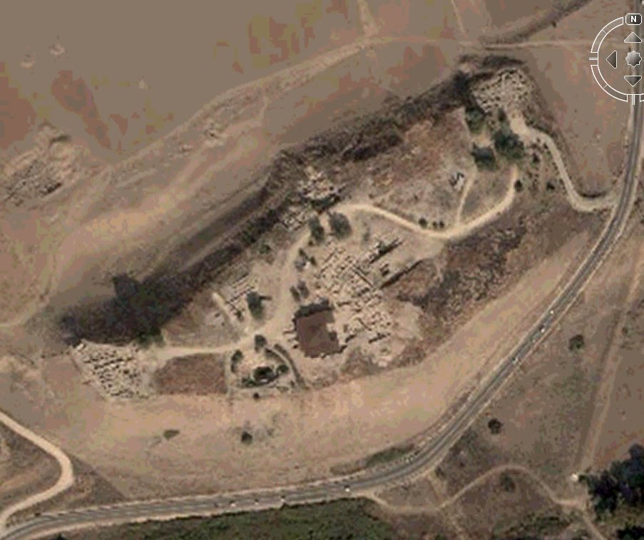 Note the fine resolution for a satellite photo.
 |
| HolyLand 3D | 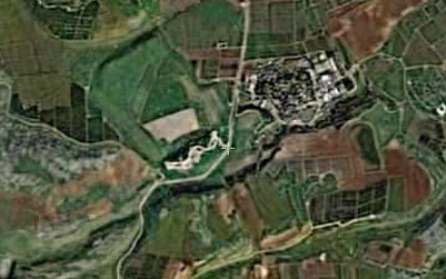 |
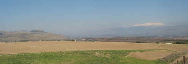
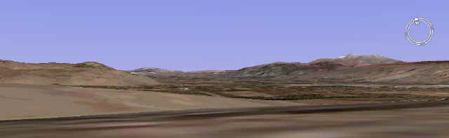
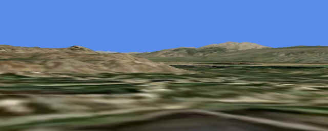
| The following photos compare an actual picture I took with screen shots that can be generated in GoogleEarth and Microsoft Virtual Earth. Both use altitude data to display accurate topography. By moving one's perspective to ground level, then tilting the view up, one can see how they can nearly duplicate an actual ground level picture. | |
| Hazor: View to Mt. Hermon
(MGVH pic 1/2007) |
 |
| Google Earth
View from Hazor to Mt. Hermon |
 |
| Microsoft Virtual Earth View from Hazor to Mt. Hermon |
 |
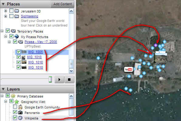
| GoogleEarth of Capernaum
Note my own pics in Picasa geotagged with preview Blue dots are from online Panoramio pics Purple dot is Wikipedia Also note YouTube video w/ video summary of the site |
 |